


 Download(28.33KB)
 1.0.8
1.0.8
 5.24MB
7.4
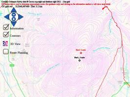
Provides useful information, 2D and 3D Open street map and OS grid references !
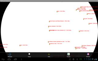
Enhanced place/walk information and maps for Android phones - with a Compass based facility to show a direction radar view or a map overlay view with potential routes.
Place information (from wikipedia and other useful information) can then be retrieved (Details).
Hills (peaks) can also be used instead of places.
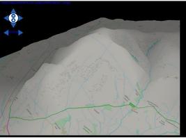
Open street map and OS vector maps for Great Britain now also available for newer devices (API level 10) and tablets for more detailed walk planning. Offering better resolution / height shading / contours and route tracking / planning.
3D OS Map (of Britain) added to assist route planning and direction / bearing finding.
Track and routes overlaid to aid navigation and route planning.
 Similarity
January 22, 2026
January 22, 2026
January 21, 2026
January 21, 2026
January 21, 2026
January 21, 2026
January 21, 2026
January 21, 2026
January 21, 2026
January 20, 2026
January 20, 2026
January 20, 2026